 Try this demonstration of
earthquake movement. Shape modeling clay into two blocks or get two
firm sponge blocks. Press the sides of the blocks together while trying
to slide them slowly past each other. You may notice that they stick at
first, then suddenly slide. This is much like what happens when earth's
plates (large sections of earth's solid upper layers) are forced past
each other causing earthquakes, whether one plate slides and bumps past
another or one moves over the other. However, slow moving 'silent'
quakes have been discovered occurring deep beneath Washington state and
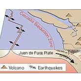
British Columbia, Canada. Here the Juan de Fuca Plate is being forced
below the North American plate, but the movement has been so slow, it
was not originally detected by seismograph analysis. It was data from
the satellites in the GPS (Global Positioning System) that detected the
very slight movements of stations on the ground.
Try this demonstration of
earthquake movement. Shape modeling clay into two blocks or get two
firm sponge blocks. Press the sides of the blocks together while trying
to slide them slowly past each other. You may notice that they stick at
first, then suddenly slide. This is much like what happens when earth's
plates (large sections of earth's solid upper layers) are forced past
each other causing earthquakes, whether one plate slides and bumps past
another or one moves over the other. However, slow moving 'silent'
quakes have been discovered occurring deep beneath Washington state and
British Columbia, Canada. Here the Juan de Fuca Plate is being forced
below the North American plate, but the movement has been so slow, it
was not originally detected by seismograph analysis. It was data from
the satellites in the GPS (Global Positioning System) that detected the
very slight movements of stations on the ground.Far offshore from Oregon, Washington, and British Columbia, the Pacific Plate and the Juan de Fuca Plate are being forced apart by convection currents in earth's mantle. (See the ScienceIQ Geology fact on Plate Tectonics from 11/02.) This moves the Juan de Fuca plate eastward where it collides with and is subducted under the North American plate. But not all parts of the massive plates move equally. Deeper in the earth, the subducted portion of the plate becomes pliable as it is heated, and it moves more easily, while colder, shallower sections of the plate get stuck, and pressure continually builds. This would be like forcing your fingers into a narrow opening. Some fingers might slide in easily, but you would feel pressure build up on the stuck fingers. The continued sliding of the moving fingers - or plate sections - does not reduce total stress because it causes stress to increase in the locked zones.
Since
plate movement in the pliable regions is so slow, the massive
earthquake energy is also being released very slowly, and no quaking is
noticed. Scientists think the energy being released is equivalent to
what would normally occur during a 6 to 7 magnitude quake, but is being
released over weeks, not seconds, so the smaller quakes are much less
powerful. The end result, however, may not be less destructive
earthquakes. Since pressure builds up in the locked zones of plate
boundaries, the energy may later be released in a quake of much greater
magnitude. If the movement occurred at the western edge of the Juan de
Fuca plate, devastating tsunamis could be generated and the entire
region would be shaken. Such a release is believed to occur somewhere
along the Juan de Fuca's boundaries about every 500 years in massive 8
or 9 magnitude earthquakes. The sensitive GPS detection of even very
slight surface movements may provide a means of predicting such quakes,
allowing advance warning.